Generator Settings
intermediate featureAll of Voxel Combat Zone is driven from the Combat Zone Generator asset. Its custom inspector groups the knobs into General, Features and Advanced, plus the Plan Preview minimap and a Regenerate button for play-mode iteration.
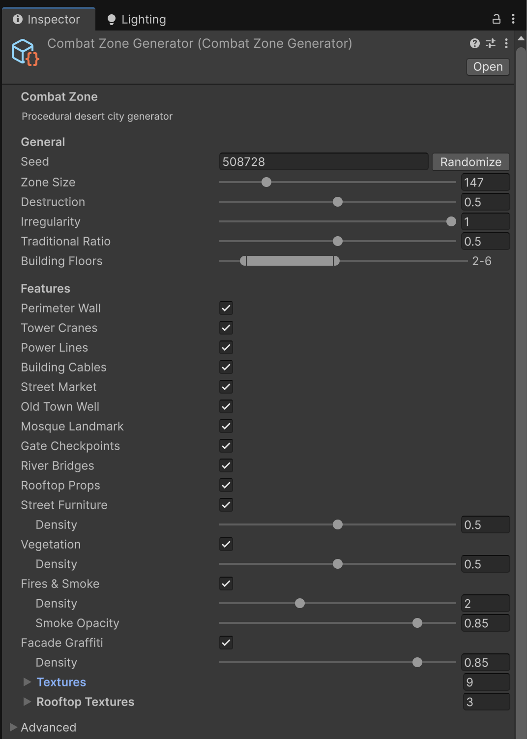
General
| Setting | Range / default | Effect |
|---|---|---|
| Seed | integer | Master seed. The same seed reproduces the same city. Use Randomize for a fresh one. |
| Zone Size | voxels (e.g. 128–147) | Side length of the city in voxels. Larger zones mean more buildings and longer world-load. |
| Destruction | 0–1 (0.5) | Overall war damage: building wear, collapses and craters. 0 = pristine, 1 = doubled damage. |
| Irregularity | 0–1 (0.5) | Street and lot layout: 0 = perfect grid, 0.5 = organic city, 1 = chaotic bazaar fabric of straight runs with doglegs. |
| Traditional Ratio | 0–1 (0.5) | Share of low-rise old-town fabric vs modern blocks. |
| Building Floors | min–max (2–6) | Storey count range for modern buildings. |
Features
Each feature is an independent toggle; several have a density slider. Toggling a feature does not reshuffle the rest of the layout.
| Toggle | What it adds |
|---|---|
| Perimeter Wall | Defensive wall ring with gates at street crossings and watchtowers at corners. |
| Tower Cranes | Lattice construction cranes over the skyline. |
| Power Lines | Street power poles with catenary cables. |
| Building Cables | Facade-to-facade alley cables (with hanging laundry). |
| Street Market | A souk of market stalls. |
| Old Town Well | A stone well in the traditional quarter. |
| Mosque Landmark | A walled courtyard mosque with a dome and slender minaret; never fully collapses. |
| Gate Checkpoints | Sandbag nests, hedgehogs and striped barriers at wall gates. |
| River Bridges | Bridges where the widest streets cross a river (needs a world with water). |
| Rooftop Props | Water tanks, antenna masts and satellite dishes on surviving roofs. |
| Street Furniture (+ Density) | Wrecked cars, dumpsters, benches, oil drums and sandbag stacks. |
| Vegetation (+ Density) | Dry scrub, weeds, date palms and olive trees reclaiming the ruins. |
| Fires & Smoke (+ Dynamic Lights, + Duration) | Burning buildings and battlefield smoke columns. How thick and how dark the smoke reads is a Voxel Play environment setting, not a Combat Zone one: see Fire and smoke look. |
| Facade Graffiti (+ Density) | Texture-stamped graffiti on facades, interiors, rooftops and walls. |
The Textures and Rooftop Textures foldouts hold the graffiti stamp sets used by the facade and rooftop passes.
Advanced
| Setting | Effect |
|---|---|
| Base Level | Reference base altitude for the layout. |
| Street Width | Default roadway width in voxels. |
| Vacancy | Share of empty lots (rubble fields instead of buildings). |
| Kerbs | Crisp cubic kerb at road edges (forces the bordering terrain to render cubic instead of being rounded by smooth terrain). |
Fire and smoke look
Whether a district burns is a Combat Zone setting: the Fires & Smoke toggle, its Dynamic Lights and its Duration are per district, so one district can burn and its neighbour stay cold.
How the smoke looks is not. Thickness, opacity, tint and the size of the puff pool belong to Voxel Play, which keeps one value for the whole world, so Combat Zone does not duplicate them. Select the Voxel Play Environment object in your scene and open the Rendering section: the pool is under Smoke Particles (Smoke Pool, Puffs / Frame) and the rest under Voxel Fires (Smoke Density, Smoke Opacity, Smoke Tint, plus range, spread and default duration).
Several districts in one world
A district and a city are the same thing in Voxel Combat Zone: one walled town, built by one Combat Zone Generator asset. There is nothing smaller inside it and nothing larger above it, so wherever a setting says "district" you can read "city".
How many districts you get

There is no "number of districts" field anywhere. The number of districts is simply how many Combat Zone Generator assets are listed in your world's Detail Generators: three entries mean three districts, ten entries mean ten districts. In the multi-district demo above there are five entries, but only the first three are districts: the City Connector and the Dressing generator are one per world, not districts of their own. Remove an entry (or clear its Enabled flag) and that district is not built. To add another one, duplicate an existing generator asset, give it a fresh Seed, and add it to the list.
Every district has its own settings
Each district is a separate asset holding a complete, independent copy of everything on this page: seed, zone size, destruction, irregularity, building floors, every feature toggle and density slider, the building palette, the voxel definitions and the graffiti sets. A small intact village and a large flattened city can sit in the same world and share nothing.
Two settings are the exception, because the City Connector decides them for the world as a whole:
| Setting | What happens when there are several districts |
|---|---|
| World Center | The City Connector chooses where every district goes and writes its own value over this one. |
| River Bridges | The City Connector builds the river crossings for the whole world and switches this off on every district. |
Where you edit each district
A district lives in its own asset. Select that asset in the Project window and you get the full inspector described on this page, with its own Plan Preview. Five Combat Zone entries in Detail Generators means five assets, edited one at a time.
The Settings object in the demo scenes
The demo scenes also carry a Settings object in the Hierarchy. It is not a district and it is not the world: it is a small demo component whose Generator field decides which single district it embeds below it. Everything under that point belongs to that one district.

When the world holds more than one district the object says so and names them all, marks the one you are editing and lets you switch to any other without leaving the Inspector. Each row also has a Ping button that highlights that district's asset in the Project window.
Below the districts, a World Systems block lists the generators a world has exactly one of, the City Connector and the Dressing generator, each with the same jump and Ping buttons and marked when disabled. It only appears when the world actually has them.
Note the count: the world in the capture lists five Detail Generators but reports three districts, because the City Connector and the Dressing generator are one per world and not districts of their own.
What the City Connector decides
Add a single City Connector Generator to the same Detail Generators list and it takes charge of everything that belongs to the world rather than to one town: where the districts sit, the highways joining them and the crossings over water. Clear its Enabled flag and it stops doing all of that: no highways, and every district keeps the World Center and the River Bridges setting you gave it.
The Connector's own inspector groups its settings into folded sections (District Layout, Road Network, River & Bridges, Terrain Handling, Furniture & Voxels) and ends in a Distribution Preview: a top-down map of the world drawn from the Connector's own plan, with each district numbered inside the bounds it occupies, the highways and bypasses joining them, the river, and numbered markers where the bridges cross. It reads the plan rather than the values typed on each district, so it shows the final placement that a district's Plan Preview cannot, and each box carries the world coordinates its district landed on. It plans straight from the terrain generator, so it works inside the Editor without generating the world. Planning every district takes a few seconds, so it never runs on its own: press Compute next to the Distribution Preview heading to build it, and Refresh to rebuild it after a change.

| Setting | Effect |
|---|---|
| Randomize District Centers | On by default. Before anything is built, the Connector looks for dry, level, well separated sites that a road can reach and moves every district onto them, replacing the World Center typed on each district. Turn it off to place your districts by hand. |
| Seed | The seed of the placement itself. Change it for a different arrangement of the same districts. |
| Layout Center, Layout Half Extents | The rectangle of the world the districts are allowed to land in. |
| Min District Gap | Clear ground kept between the edges of two districts, not between their centres. |
| Max Neighbour Distance | Every district must have another one no farther than this, so none ends up stranded. |
| River District Count | How many districts must be placed beside water. |
| Disable District Bridges | On by default. Leaves every crossing to the Connector's own viaducts and switches the per-district River Bridges off. |
| Network, Road, City Accesses, Terrain Handling, River Viaducts | How the districts are linked, the width, shoulders and dashed centre line of the carriageway, the bypass around each city, the slip roads down to the wall gates, the steepest gradient the road accepts, and the span, clearance and piers of the viaducts. |
The Dressing generator
The open desert between the districts is dressed by its own asset, Combat Zone Dressing Generator (Create > World Play > Combat Zone Dressing Generator). One of them dresses the whole world, so the cost is paid once however many districts there are, and two districts can never scatter their outskirts on top of each other. It reads each district's centre and zone size to keep out of them; the districts know nothing about it.

| Setting | Effect |
|---|---|
| Seed | Seed of the scatter. Change it for a different arrangement of the same props. |
| Districts | The districts to keep clear of. Leave it empty and every Combat Zone generator in the same World Definition is picked up automatically. |
| District Margin | Extra voxels of bare ground kept around each district, so the desert dressing does not crowd the perimeter wall. Default 4. |
| Rocks, Vegetation, Trees | One switch and one density slider each, for rock outcrops, ground weeds and palms. |
| Voxels | The definitions used for the scatter: rock outcrops, ground cover (CutoutCross definitions), palm trunk, foliage and the pole voxel used for olive canopies and as the palm trunk fallback. Use the same rubble voxel the districts use so the ground reads as one desert. |
The dressing also keeps clear of the highways, so nothing is scattered on the carriageway or its shoulders.
Planning for many districts
The Connector places districts by trying random sites inside Layout Half Extents and rejecting any that are under water, too steep, too close to another district or impossible to link by road. The default rectangle and the default Min District Gap are sized for a handful of districts; ask for ten at those values and there is not enough room, so the search gives up, a warning appears in the console and the districts stay at the World Center values you typed. For many districts, enlarge Layout Half Extents, lower Min District Gap, or both, and raise Max Neighbour Distance to match.
Bear in mind too that every district is a full asset of its own: ten districts mean ten copies of the palette, the voxel definitions and the graffiti sets to keep in step, and ten city plans held in memory while the world runs.
Suggest an improvement
Help us improve this documentation page.